


不宜碇泊區:牛尾洲 (No-anchoring Area: Shelter Island)
海岸公園及保護區
香港郊野
2023-07-24 (一), 13:00
請勿在牛尾洲「不宜碇泊區」拋錨
Not to anchor in “No-anchoring Area” of Shelter Island
牛尾洲
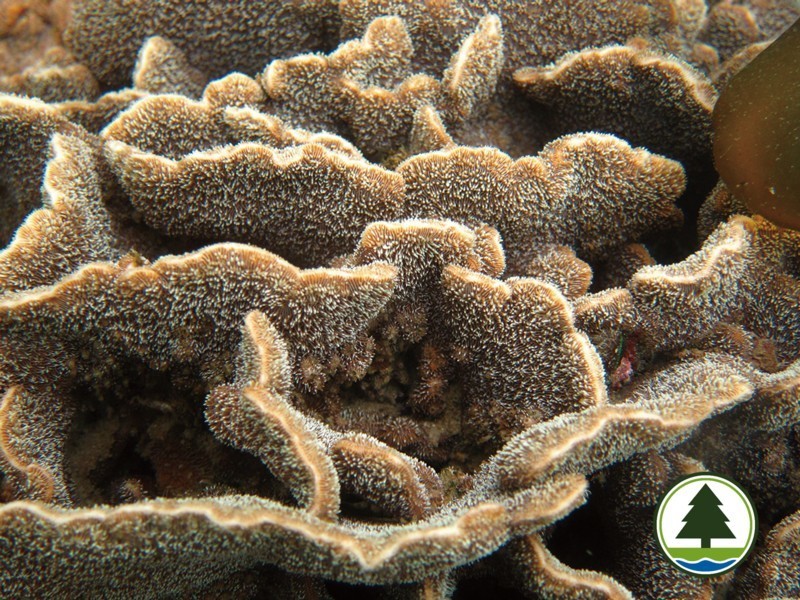
牛尾洲位於牛尾海內,座落在橋咀洲西南二千米處,距離西貢市中心約六千米,正面對著西貢的清水灣。牛尾洲的珊瑚群落主要生長在該島的北面。珊瑚覆蓋率高達60%,大部分的品種是珍貴的蜂巢珊瑚 (Favites sp.)及在世界上少有,但在香港是優勢品種的扁腦珊瑚 (Platygyra sp.)。在二零一五年五月,漁農自然護理署在牛尾洲北面設置「不宜碇泊區」,減低船錨對珊瑚的破壞。
「不宜碇泊區」位置
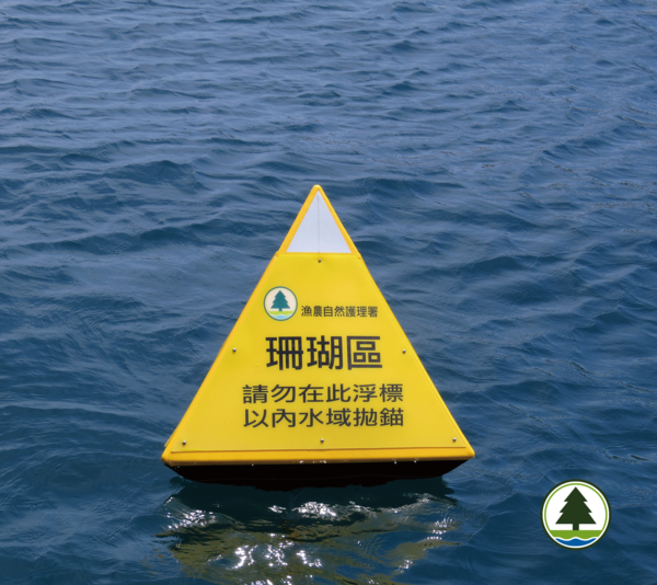
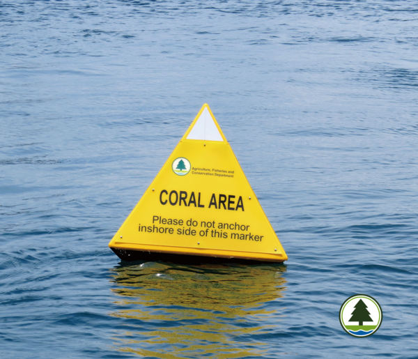
「不宜碇泊區」位置設立在牛尾洲的北面,由4個印有「珊瑚區 請勿在此浮標以內水域拋錨」黃色珊瑚標誌浮標劃出珊瑚覆蓋率高的範圍,提醒駕駛船隻人士避免在該範圍下錨停泊。其位置見地圖所示,該處範圍近岸位置長有珊瑚。
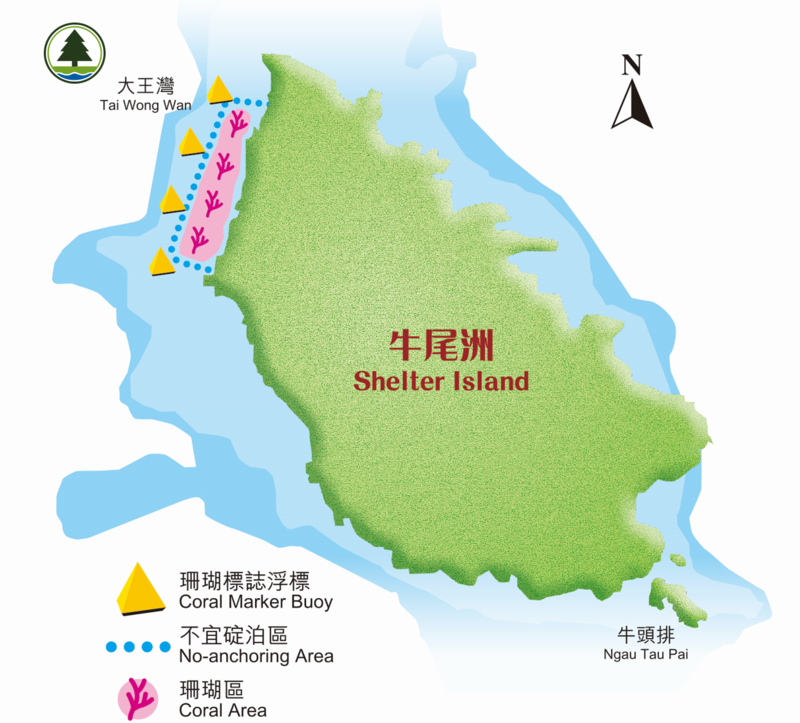
Shelter Island
Shelter Island is situated in Inner Port Shelter. It is located at about 2km southwest of Sharp Island, 6km from Sai Kung Town Center and opposite to the Silverstrand in Sai Kung. The corals are mainly located on the northern side of the island. 60% of coral coverage were found. Majority of the coral species in this area are uncommon Favites sp. and rare internationally, but dominant in Hong Kong Platygyra sp. In May 2015, AFCD set up a “No-anchoring area” at Shelter Island in eliminating impact of anchor damage on corals.
Location of the “No-anchoring area”
“No-anchoring area” was set up at the northern side of Shelter Island, indicated by 4 yellow coral marker buoys marked with “Coral area Please do not anchor inshore side of this marker” to mark off areas with high coral coverage and notify the marine users to avoid using the area for boat anchoring. The location of which is marked in the map, close to the shore contains fragile coral communities.
珊瑚的特性
Characteristics of corals
船錨對珊瑚造成的威脅
Anchor threat to the coral
「不宜碇泊區」功用
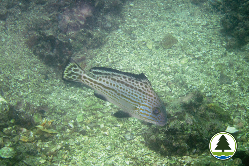
為保護珊瑚,「不宜碇泊區」作用能有效提醒駕駛船隻人士應避免在「不宜碇泊區」內下錨停泊。提醒駕駛船隻體型較大的人士應避免駛進「不宜碇泊區」或其他淺水珊瑚區以免造成擱淺、損毀珊瑚及船身。能提醒水肺和徒手潛水人士該處為珊瑚區,請遵守海洋護理守則,初學水肺潛水的人士,若未能純熟控制浮力,亦應避免在珊瑚區進行潛水活動。
Function of the “No-anchoring area”
To protect corals, “No-anchoring area” can be used as an indicator for the vessel operator to avoid anchoring their boats inside the “No-anchoring area”. To remind operator of vessels with considerable size not to enter the “No-anchoring area” and avoid sailing over any shallow coral area, as this may cause groundings, damage large area of corals and the vessel itself. Also remind the divers and snorkelers, to observe and follow the best environmental practices when visiting the coral sites where this area is with high coral coverage. Novice SCUBA divers who do not have good buoyancy control skill should also avoid diving at coral sites.
漁護署工作
監察珊瑚標誌浮標的效用,並且透過宣傳教育,推廣「不宜碇泊區」的設立和功能。
Work of AFCD
Monitor the effectiveness of the coral marker buoys and promote the existence and functions of the “No-anchoring area” through education and publicity.
資料及圖片提供:漁農自然護理署 (AFCD) ,授權轉自《漁農自然護理署(漁護署)》
資料整理:野外動向 HK Discovery Team

